Sustainable urban development in its complexity is one of the
most critical issues today and it is also reflected in numerous recent
policy commitments and targets from global to local level. Understanding
of complex relations of urban versus non urban land both on the level
of physical forms and material & energy flows are recognised as
crucial for balanced economical, ecological and social inclusive
sustainable development.
 USER NEEDS DRIVEN
Urban Sprawl is a Europe-wide serious problem, not only due to
total area taken, but also due to its spatial distribution patterns
(leading often to landscape fragmentation) and the composition of land
taken (mostly agriculture and natural areas are converted to artificial
areas). Finally, also the utilization of urbanized area (no. of
inhabitants, no. of jobs) has to be taken into account to assess
sustainability of urban development. Land is a finite resource and
therefore urban planners need to select land to be used for further
development more wisely applying the concept of land recycling. There is
a need for a user-oriented service facilitating the identification of
suitable sites for redevelopment based on objective criteria and
providing flexible insight into these trade-offs on a strategic level
for specific areas, still keeping in mind the general policy context.
URBIS services will initially focus on the development of services
focused on strategic users, but later on it will deal with operational
users too:
- Strategic users, such as local and
regional authorities, European and national agencies in charge of urban
planning, would directly benefit from URBIS services as for the
monitoring of the implementation of particular territory planning policy
(e.g. the 30 ha goal on reduced land consumption in Germany).
Furthermore, URBIS services may be used to support the allocation,
monitoring and evaluation of ERDF funds in urban areas, or to assess to
which extent urban development is meeting targets for the redevelopment
of vacant sites.
- Operational users, such as industrial
estates operators, private land developers or financial institutions are
likely to require the URBIS services for meeting their requirements for
information on suitable vacant sites location within metropolitan areas
for the specific constructions or to improve project business plans.
Regional and local planners also need information on the different
vacant land development options as a critical component of urban and
regional planning and spatial land management issues i.e. urban sprawl,
nature conservation and leisure areas and green infrastructure
connectivity etc.
The development of URBIS thematic services requires closer
interactions with a wide range of stakeholders. URBIS partners already
cover a wide range of the land use management processes. However, an
external Stakeholder Board is created to ensure that the URBIS services
address comprehensively all processes and actors involved. URBIS
services initially focus on the development of services focused on
strategic users, but later on will deal with operational users too.
 EO TECHNOLOGY BASED
Copernicus programme generate large number of standard
open-data, Earth Observation datasets as well as standard services
(Urban Atlas, High Resolution Layers (HRLs)), which can be utilized for
urban land recycling policy support. More also other public initiatives
under the European Open Data Strategy generate number of other
supportive information. Several research and development projects were
conducted notably by the project partners around feature extraction
within the urban environment and identification of vacant urban sites.
The techniques developed based on data fusion and Object Based Image
Analysis (OBIA) makes it possible to ingest a large amount of data and
automate the identification of vacant urban sites. The following mature
technologies will serve as a basis for URBIS services implementation:
- Heterogeneous data collecting and processing (historical data, aerial
photos, satellite imagery, existing data bases)
- Extraction of urban patterns from Very High Spatial Resolution (VHSR)
data and scene complexity
- Characterization of land cover in urban and vacant areas: identification
of objective criteria.
Although large amount of data will be used to implement the
service, the end-product will be compatible with standard GIS
technology. It will also be possible to disseminate through OGC
compliant web geo data portals with advance presentation capabilities
(e.g. D3 documents). Such topic is Europe-wide and therefore also such
focused service has Europe-wide potential for commercial exploitation.
Nevertheless till now transferability and scalability of such services
was questionable due to heterogeneity of input data needed in different
European countries. In contrary, recent developments in standard
open-data provision as Copernicus datasets and other public data
available in line with principles of the European Open Data Strategy
(2011) and strengthened by the European INSPIRE harmonization effort,
make hight potential for the operation use of EO datasets in this
domain.
 OPERATIONAL SERVICES
The URBIS project aims to developp, implement and validate in
real environment innovative information services related to urban vacant
land recycling, based on open geospatial data, to support planning of
European Large Urban Zone’s (LUZs) in a sustainable way. The innovative
URBIS services that will be developed and implemented during the project
are articulated around 3 main categories:
- Baseline services: an initial inventory
and typology of urban land, to identify sites that can be used for
re-development, but also that should be preserved,
- Update services: a regular update of the vacant urban land inventory,
- Thematic services: downstream services
derived from the URBIS baseline and update products, set for both the
public and private sectors, and meeting their specific needs.
The URBIS project aims to support European spatial urban
planning in general and land use planners and land (re-)development
agencies in particular and will answer the needs of strategic and
operational users in this field (regional & local authorities, urban
development agencies, national & EC level institutions). Vacant
urban land can present very different characteristics depending on the
level of development and previous use of the land. As a result,
depending on their size, location and previous use, they could be
redeveloped with minimum inputs (e.g. development of a green park from
fallow land with no previous use) or will require substantial
remediation work (development of a housing estate on potentially
contaminated land). The lack of knowledge about site condition and
characteristics often hampers their redevelopment. Although information
exists locally, it is often patchy, incomplete and spread over different
organisations. Moreover, there is a lack of consistent information at
European level making it difficult to exchange and compare data.
Nevertheless, nowadays conditions exist for the development
and implementation of a methodology to set up European information
services on vacant land. URBIS project will identify, develop and
validate operational potential of standard open-data provided under
Copernicus programme and other public initiatives under the European
Open Data Strategy for land recycling support. The development of such
an information services under sustainable business model could provide
major suport in the promotion of recycling existing urban sites thus
contributing to the reduction of urban sprawl in Europe.

GISAT
GISAT S.R.O.
Praha, CZECH REPUBLIC
Mr. Tomáš Soukup

SIRS
SYSTÈMES D'INFORMATION À RÉFÉRENCE SPATIALE (SIRS) SAS
Lille, FRANCE
Mr. Christophe Sannier

UOS
UNIVERSITAET OSNABRUECK
Osnabrueck, GERMANY
Mr. Norbert de Lange

UNIGE
UNIVERSITA DEGLI STUDI DI GENOVA
Genoa, ITALY
Mr. Sebastiano Serpico

STADT+
DR. FERBER, UWE UND GRAUMANN, DOREEN PROJEKTGRUPPE STADT + ENTWICKLUNGS
Leipzig, GERMANY
Mr. Uwe Ferber

ADUGA
AGENCE DE DEVELOPPEMENT ET D'URBANISME DU GRAND AMIENOIS ASSOCIATION
Amiens, FRANCE
Mr. Jérôme Grange
URBIS Solutions aim to assist in responding effectively to the societal challenges of our time, in transforming our cities and city-regions. However, the interconnectedness of socio-economic and environmental challenges in the urban context create complex conditions for urban management, and barriers to the delivery of a more sustainable urban development.
URBIS Solutions offer, for example, integrated assessments of city-wide land use development potential, targeting brownfield sites, specifying green infrastructure as a strategic structuring principle for urban development, and contextualising development assessments according to the ambient demand and supply for development in relation to plan objectives.
URBIS Solutions have been developed specifically to support city managers in this transformational governance, exploiting “open” European data including Copernicus data, and deploying the latest analytical methods to meet a wide range of user requirements for assessment, evaluation and communication tools including:
Interactive web-based user communication platform supporting visualization, assessment, evaluation, and benchmarking, etc.
Nature-based solutions to societal challenges are inspired and supported by nature as living solutions. They are adaptable, multi-purpose and resource efficient, and provide simultaneously environmental, social and economic benefits including:
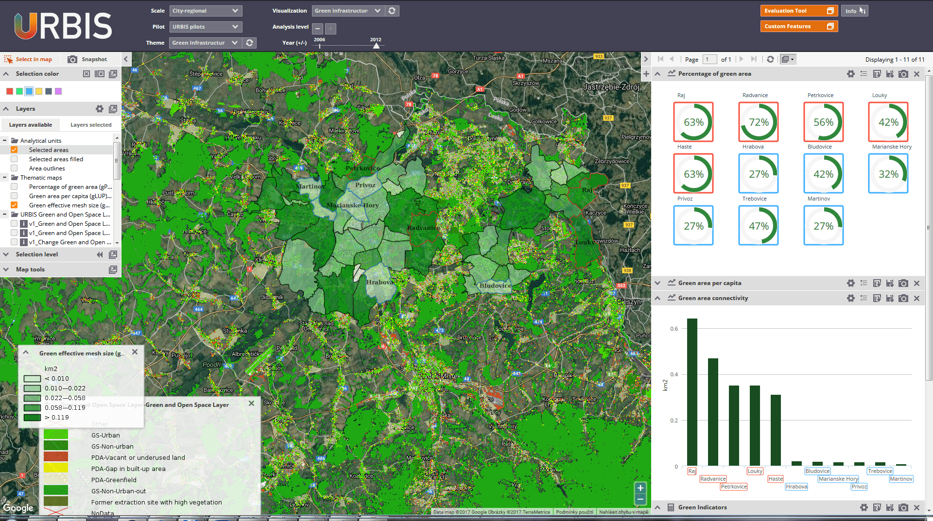
Green infrastructure planning objectives are set in the strategic planning framework that extends across the administrative boundaries from city centre to hinterland at the local level. Green infrastructure planning requirement, are fully supported by URBIS solutions, and focused on the connectivity of the network of green infrastructures, and the definition of green routeways linking city centre to countryside. URBIS solutions (See Figure) identify gaps in the network to be filled to ensure connectivity essential to meet the requirements of the policy. Gaps in the network can only filled at the local level, where neighbourhood planning is critical to the realisation of city-wide planning objectives. Overall URBIS solutions support policy development, project implementation, as well as awareness raising.
URBIS Solutions for Green Infrastructure planning and connectivity (Re-Naturing the City) are based on URBIS Green and Open Space Layer dataset and include following elements:
Urban sprawl defined as ‘unplanned incremental urban development, characterised by a low density mix of land uses on the urban fringe’ (EEA, 2006) has different impacts depending upon the type of land use involved (residential, industrial, commercial, etc.) and what land is being consumed (agriculture, forest, etc.). Agricultural land is generally the dominant land-use in peri-urban areas, and this land use suffers of rapid changes. Urban sprawl and the uncontrolled expansion of built development and infrastructures of transport around cities:
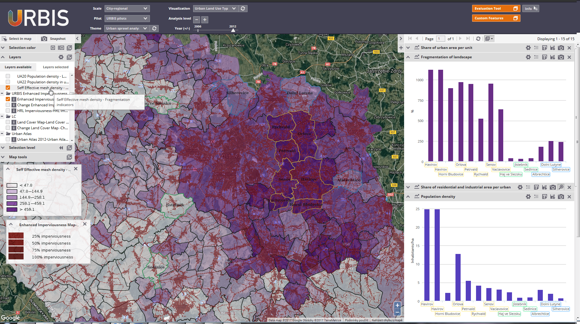
Compact cities form critical elements in strategic policy frameworks to counteract urban sprawl. URBIS solutions support public authorities in resisting pressure by market actors generating urban sprawl, reinforcing governance-based planning interventions resisting supporting compact cities. URBIS urban sprawl dynamics intelligence (See Figure) identifies the rate of urban sprawl in peri-urban and the urban hinterland, and supports critical analysis regarding loss of agricultural soils, as well as the health of ecosystems and habitats. URBIS solutions help to guide strategic priority setting and decision-making at local and regional levels. Overall URBIS solutions support policy development, project implementation, as well as awareness raising.
Urbis Solutions - Urban Sprawl Dynamics are based on URBIS Enhanced Imperviousness Layer, Land Cover Map and include following elements:
Potential development sites can include for, example, brownfields sites as well as other vacant and underused areas within the existing urban environment. The re-use of these sites supports sustainable land use management objectives, including the minimization of land consumption and de-sealing initiatives, as well as an opportunity to rethink city planning and improve urban design:
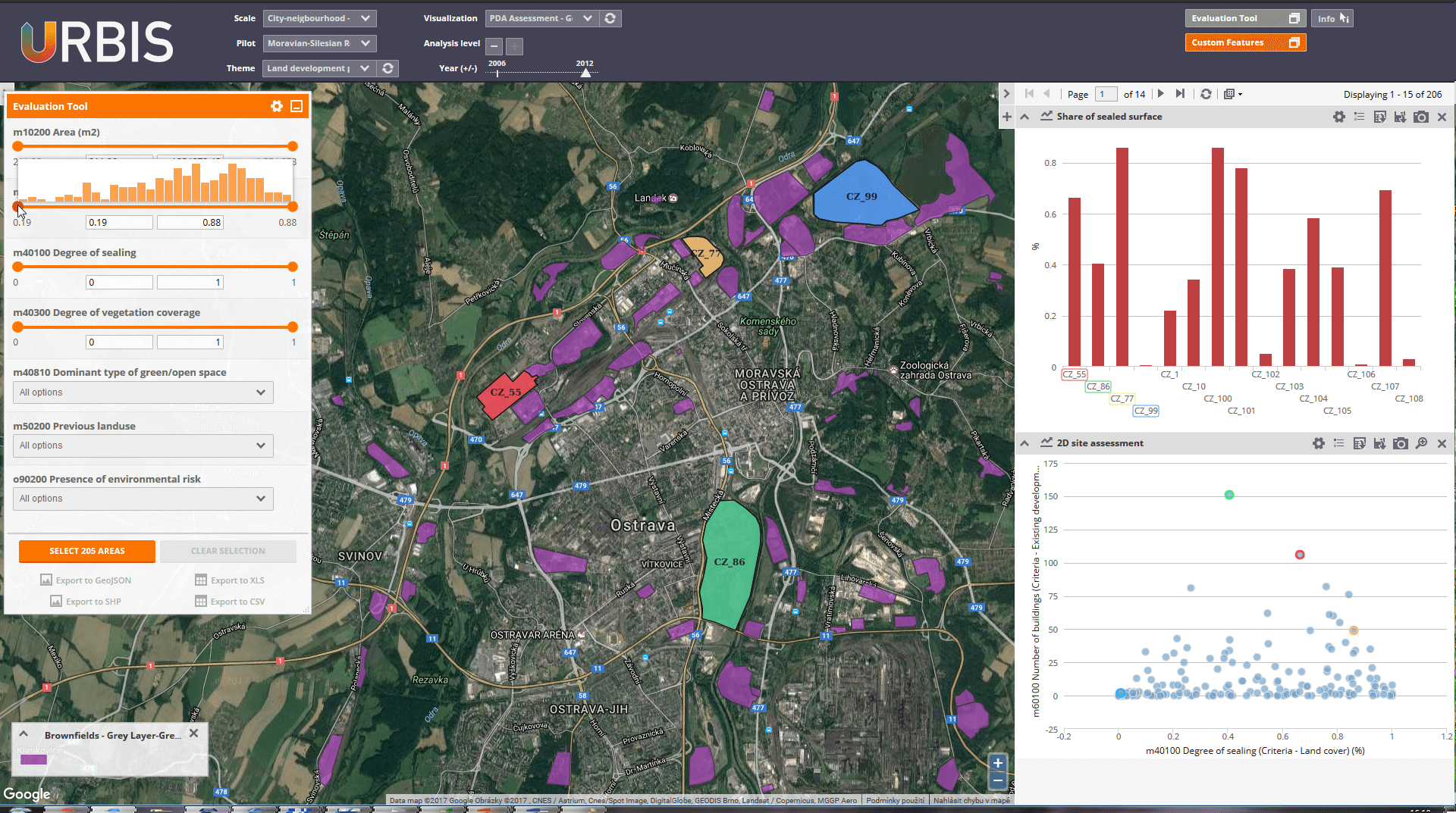
URBIS Land Development Potential assessments complement the URBIS sprawl dynamic assessment in the city regional context by providing detailed assessment within existing urban areas. URBIS solutions identify and classify sites according to their development potential, and suitability to accommodate a wide range of new urban uses. URBIS Land Development Potential assessments (See Figure) provide a first estimate of the type, scale and distribution of sites available for urban redevelopment. These assessments offer local stakeholders and authorities an improved overview of inner city development potentials, as a basis for further investigation and site development. Overall URBIS solutions support policy development, project implementation, as well as awareness raising.
URBIS Solutions – Land Development Potential is based on URBIS Grey Layer and change and URBIS Green and Open Space Layer and include following elements:
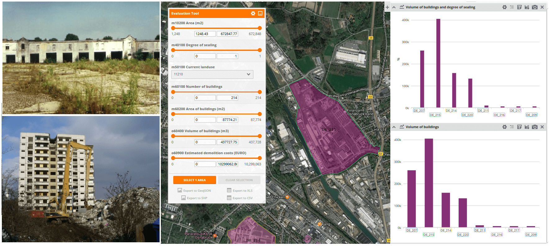
The creation of new urban uses, supports a range of policy objectives including the development of more compact cities, delivered by mixed use developments, connected by green infrastructures in the heart of the city. This regeneration, transformation, and restructuring of cities often requires the demolition of buildings and infrastructures. Demolition occurs for a number of reasons, including abandonment of the use of the structure, unsatisfactory location, deteriorating building material quality, lack of interest from property owners to invest.
URBIS Urban Renewal Cost Estimation permits full understanding and evaluation of the benefits of the renewal process, and supports full assessment of the costs of demolition activity to be presented to decision-makers including:
URBIS Solutions – Urban Renewal Cost Estimation is based on URBIS Grey Layer and include following elements:
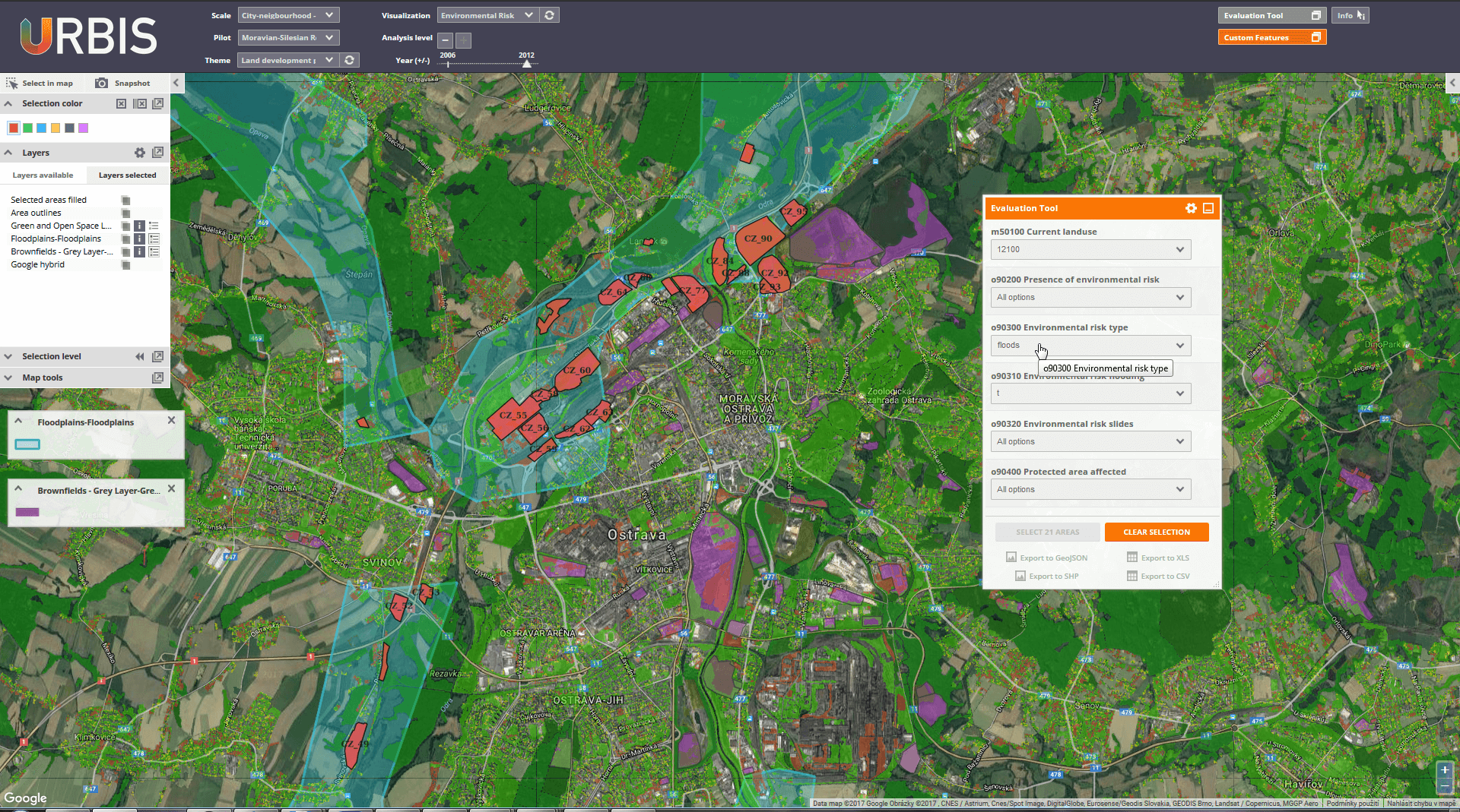
Sustainable city planning requires hazards to be mitigated where they can be anticipated, and specifically urban structures must be managed to avoid the consequences of climate change including protection against flooding, and avoidance of development in flood risk zones. At the same time the development of green infrastructures inside and around cities, offers opportunity to deploy more resource-efficient nature based solutions, so instead of building dykes against flood events, exploitation of flood areas can be secured. Comprehension of flood risk and assessment of it’s impact is therefore an essential element in decision making for the future development of the city.
URBIS Flood Risk Assessment service provides vital flood risk zone information:
URBIS Solutions – Flood Risk Assessment is based on URBIS Grey Layer and URBIS Grey Layer and include following elements:
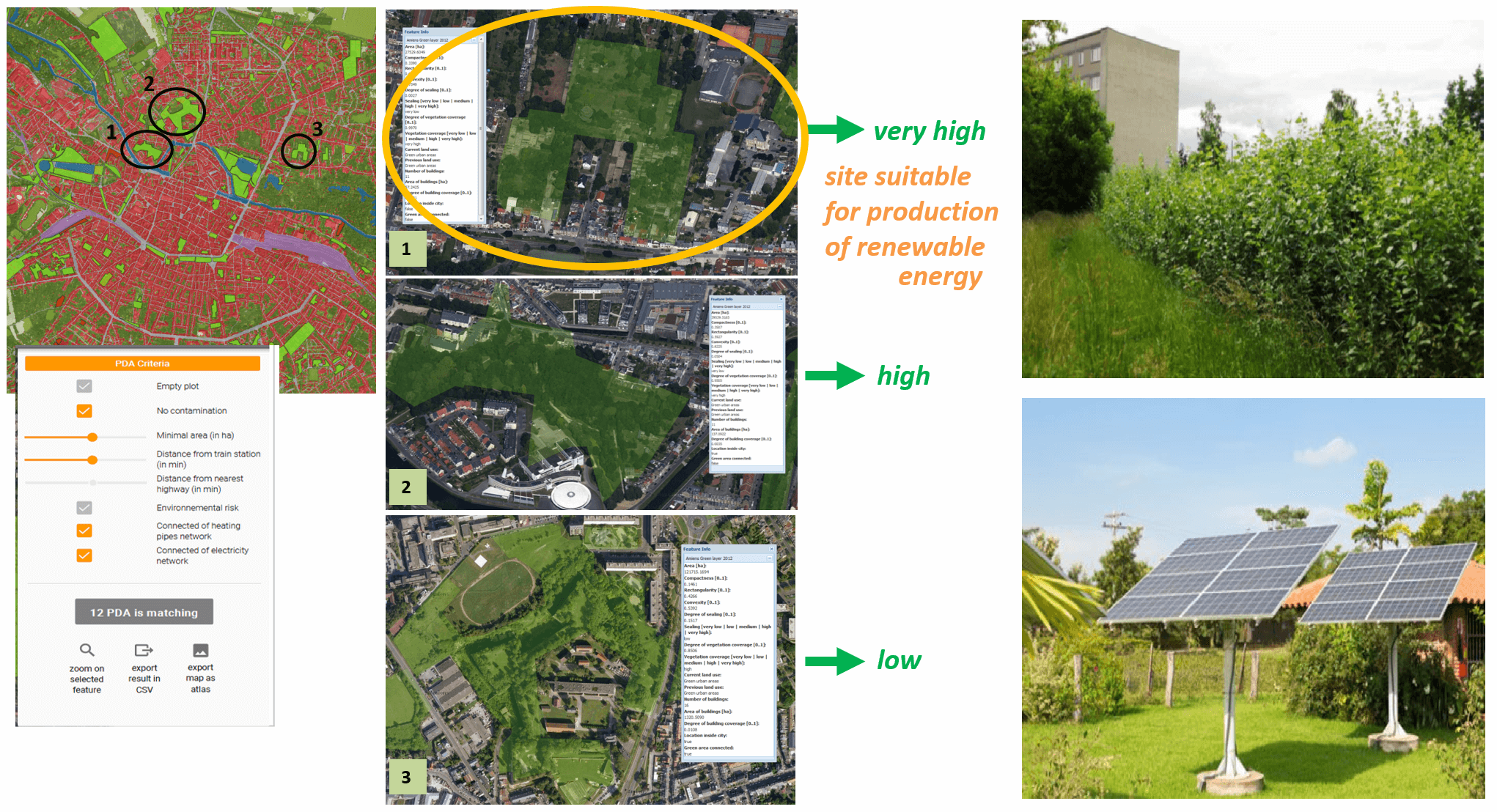
Meeting the goals of energy security and CO2-neutrality, require that cities create commonly agreed long-term strategies to frame the energy transition and ensure its viability and execution. Decentralised renewable energy production at city and city-region levels can be provided by a variety of sources including solar and biomass. Site potentials for the production of solar and biomass energy are typically unknown and unexplored, and consequently solar and biomass energy assessment tools offer huge potential to support the political needs for energy security, CO2-neutrality and the energy transition.
URBIS Solar and Biomass Energy assessment tools permit the evaluation of the development potentials of sites and specification of their suitability for generating renewable energy resources. Accordingly sites which are currently underused or vacant may provide ample opportunities for the production of renewable energies. URBIS Solar and Biomass Energy assessment tools:
URBIS Solutions – Solar and Biomass Energy Potentials is based on URBIS Green and Open space layer and include following elements:
Effective data-driven decision making requires support the decision making processes via an easy-to-use tool flexible to choose analysis level and seamless integrating data and indicators with additional information in transparent environment. In land management domain it means embedded in the integration tool, intended specifically for the assessment of the (re)development potential of the site e.g. brownfield site or vacant urban site more generally. This advanced filtering functionality shall provide ability for interactive:
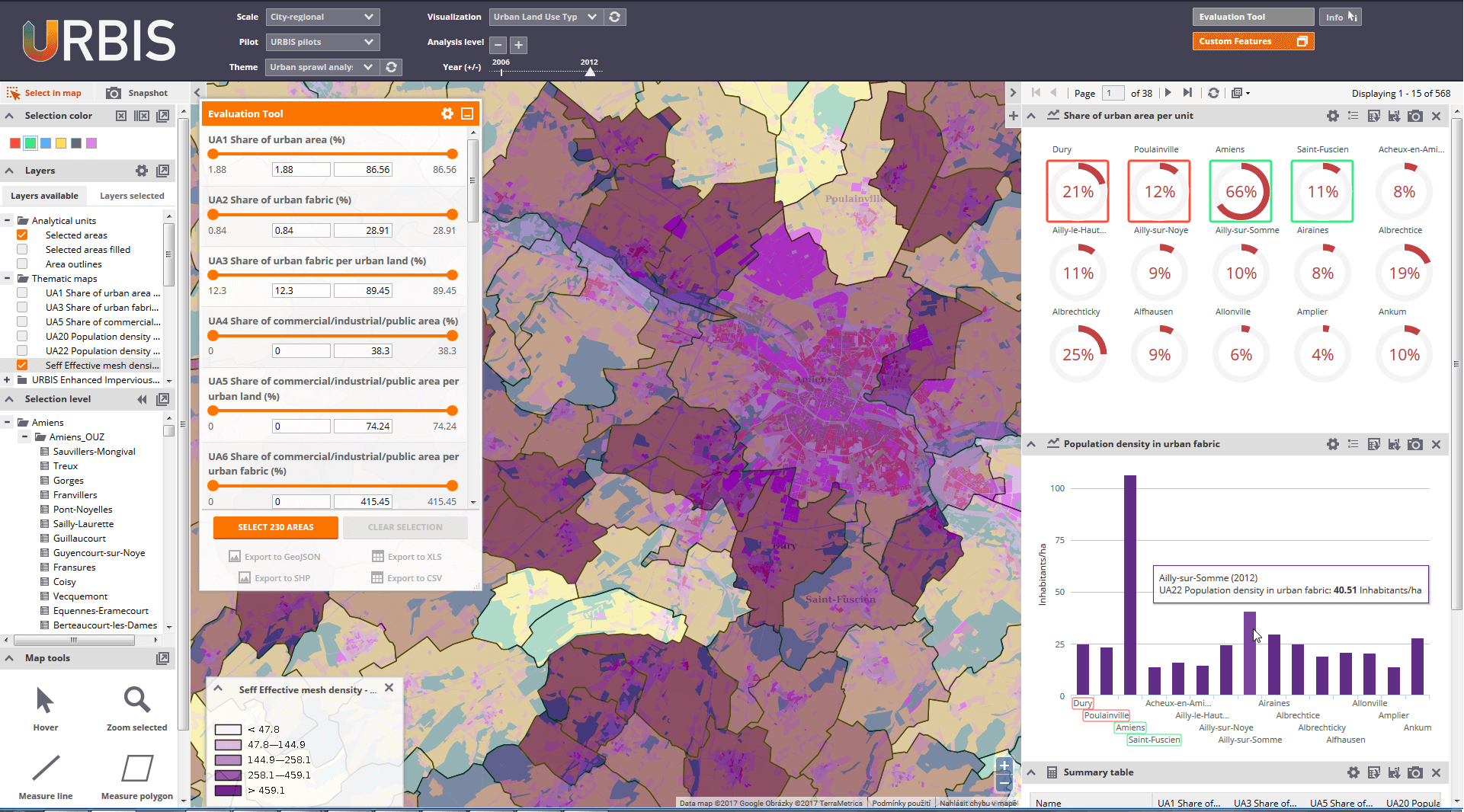
The URBIS Integration tool supports the requirement for a platform which can support interactive user driven analysis of project results and communication between the user and provider of the services. To meet this need, a web-based application has been developed, built on open source programming approaches. This URBIS Integration tool provides an environment, which supports decision making at different stages of the urban and regional planning policy development and implementation process, by providing tools for interactive multi-scale land use planning assessments of the city and the surrounding city-region.
URBIS Integration Tool enables:
The tool is available online at http://urbis.gisat.cz/tool/
Join URBIS-CABERNET workshop is planned within the CABERNET Conference 2014 on October 16th 2014 in Frankfurt, Germany.
First technical coordination meeting will be held on June 12–13th 2014 in Prague in GISAT premises. The aim of the meeting is to coordinate ongoing technical activities and discuss detailed WPs planning.
URBIS Web Pages has been launched at www.ict-urbis.eu. As part of the CI package also a new URBIS logo has been introduced.
URBIS Kick Off Meeting has been held on May 7th 2014 in Luxembourg in EU DG CONNECT premises.
URBIS project has officially started on April 1st 2014. In coming three years, our team aims to contribute to European urban sprawl management support utilizing Copernicus land services. Stay tuned, there’s more to come soon…
Velikost zobrazení mapy změňte podržením klávesy Ctrl a posouváním kolečka myši

The URBIS project consortium is lead by GISAT s.r.o.:
 Project coordinator: Tomas Soukup
 GISAT s.r.o., Milady Horakove 57, 170 00 Praha 7, Czech
Republic
GISAT s.r.o., Milady Horakove 57, 170 00 Praha 7, Czech
Republic
 Send us your feedback
![]()
Grant Agreement No. 621125

 Go to
Go to